Jun 26, 2020
In the past decade, the construction industry has invested significantly in advanced technologies that increase efficiency on jobsites. Projects that take advantage of automation and forward-thinking often set themselves apart from others. For many, the most impactful investment is commercial UAVs (unmanned aerial vehicles), or drones.
From enhanced site modeling to comprehensive project imaging, drones are changing the way we build. Projects that take advantage of drones see benefits in the form of comprehensive documentation, time and cost savings, and overall effectiveness. Below are some of the ways drones can enhance any jobsite.
Surveying
Traditional surveying methods require significant time and manpower for a relatively small amount of site data. Using drones, thousands of measurements and data points are collected in a matter of minutes. From this data, various maps of the site are produced, containing information such as topography and control points (i.e. elevation, utilities, property lines). Drones also map areas that would otherwise be difficult to survey, resulting ultimately in both faster and more comprehensive data.
Earthwork Mapping
Earthwork mapping is one of the latest services made possible by drones. By simply scanning an excavation site, extensive data points, known as cut/fill data, provide information such as the volume of materials to be removed and how much is left after the initial excavation. This process typically requires significant manpower and complicated calculations. Through automation, the process is simplified and considerably more efficient
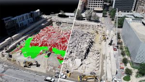
Scan to BIM
Drones are one of the latest developments in the world of BIM. Traditional quality control methods involve drawings and tape measures to verify building accuracy. Using 3D photogrammetry and LiDAR technology, drones capture the physical site in minutes. That scan is used to generate 3D content and isometric point clouds. Overlaying the point clouds on BIM models provides a comprehensive and detailed look at the project, removing human error and limitations from the process and ultimately saving time and money.
Aerial Imaging
Drones capture project milestones in dynamic, multi-angle, high-resolution photo and video. Aerial imaging offers a holistic view of the site, taking advantage of elevated views that would be otherwise impossible to capture with traditional photography. Not only is the imaging an effective story-telling tool, but it also enhances portfolios, websites, and social channels.

Remote Inspections
Buildings and structures no longer require hours-long, hands-on inspections. Drones capture difficult to reach spaces in a matter of minutes, allowing inspectors to view footage from a safe location. Additionally, inspection footage provides a comprehensive record for fact-checking and a point of comparison for future inspections. Utilizing drones eliminates significant risk and provides a faster, more cost-effective experience, all captured in high definition.